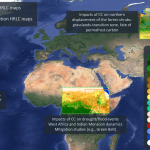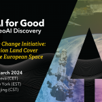
Join us for the webinar “Introduction to the High Resolution Land Cover Map” on March 12, 2024, at 16:15 PM CET, hosted by AI for Good. This session will showcase the design and application of comprehensive processing chains that exploit AI for the generation of high resolution land-cover products in the context of the ESA’s Climate Change Initiative. These processing chains are specifically engineered to handle Earth Observation data, enabling the creation of high-resolution (10/30m) maps that depict land-cover and the related changes between 1990 and 2019 at subcontinental and regional scales. The products generated in Amazonia, Africa Sahel and Siberia will be presented and the process for dowloading them illustrated.
Don’t miss this chance!
Register now: webinar